GPS Map Camera: Geotag Photos 1.3.6
Free Version
Publisher Description
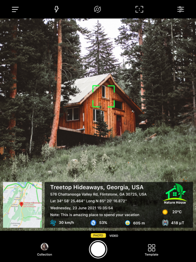
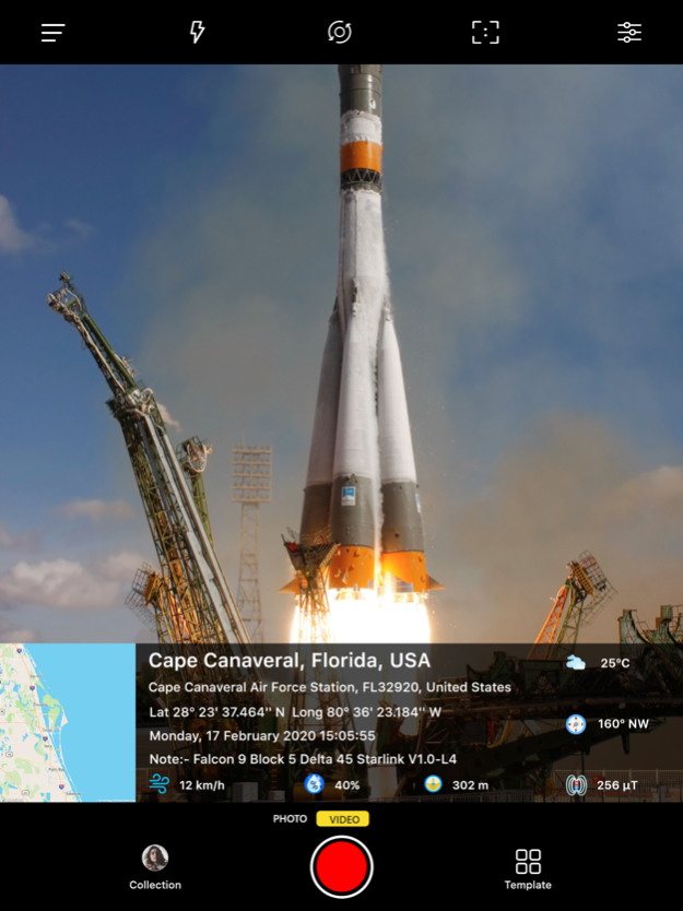
Add GPS Location stamp, Latitude Longitude stamp, Address stamp & Date TimeStamp with the help of GPS Map Camera App, also change different Style and Format of stamps
Regardless of whether It's your moment recollections or your visit at a specific destination, with GPS Map camera stamp application, add & stamp Date, time, Map, Latitude, Longitude, Altitude, Weather, Magnetic field, Compass to Your Camera Photos.
Track Live location along with your captured photos by GPS Map Camera: Geotag Photos Application. Send your Geo Location of Street / Place added photos to your Family & Friends, and let them know about your best earth travel memories and movements.
How to add GPS map location on photos?
~ Install GPS Map Camera: Geotag Photos From App Store.
~ Select Advance or classic Templates, Arrange Formats of Stamps, Change Settings according to Your requirement of GPS map Location Stamp
~ Add GPS Location stamps automatically to your clicked pictures
Interesting Features:
~ Get Custom GPS camera with Grid, Ratio, Front & Selfie camera, Flash, Focus, Mirror, Timer, capture sound Support
~ Set Map data as Automatic
~ Classic Template contains automatically fetched stamp details
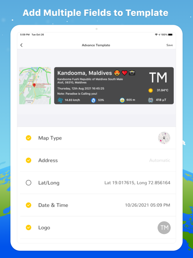
~ In Advance Template Section:
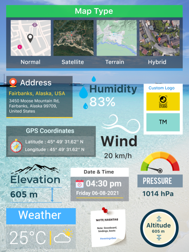
- Custom maps options: Change Map type from Normal, Satellite, Terrain, Hybrid Options
- Address: Add your selected Automatic location on the Photo
- Lat/Long: Set GPS Coordinates from DMS or Decimal Options for GPS Stamp
- Date & Time: Add Date & Timestamp from various formats as an image tag.
- Logo: Upload your own brand logo
- Note: Write relatable Notes
- Hashtags: You can also add hashtags related to your photos with this GPS app
- Weather: Either in Fahrenheit or Celsius, Measure Temperature Units
- Compass: Auto compass direction
- Magnetic Field: Auto magnetic field Details
- Wind: Measure Wind speed
- Humidity: Auto Humidity measurement
- Pressure: Measure pressure of the place
- Altitude: It will automatically calculate Altitude
- Accuracy: Get auto accuracy on image
Why to have GPS Map Camera Application in Your Smartphone
- To Add Satellite Map Stamp on Photos
- To Add GPS Map Location Stamp to Photos
- To Add Geotag Stamp on photos
- To Add Photo Location stamp
- To Add Date Timestamp
- To Add Longitude, Latitude, Address, Date Time, Location stamp to Photos
- To Check GPS tracker Stamp on Photos
- To Get Geo Location image Stamp
- Camera timestamp, having custom stamps for adding details manually
Most Efficient Application For Following Groups of People:
-Travelers & Explorers can effectively utilize Geo-tagging camera app
- People who associated with business related to real estate, Infrastructure, Architecture can easily apply GPS Map Location stamp to their Site Photos
- Individuals having Destination celebrations of events like Wedding, Birthdays, Festivals, Anniversaries, etc. Can have their current GPS location stamp on the picture.
- Anyone who wants to add GPS Details on their photo as a GPS notecam can use the App.
- Persons having outstation Meetings, conferences, Conclaves, Meetups, Events arranged by companies or Institutions solving and serving a particular purpose
- Travel, Food, Fashion & Art Bloggers can advance their experiences by adding GPS Location through GPS Map Cam
- Place Oriented businesses, where You require sending images with Live Location To Clients
For experimenting with such Interesting Features, MUST Download GPS Map Camera: Geotag Photos Application Right now in your Smartphone.
Do not forget to share your best experiences with us through Rate & Review.
Apr 10, 2024
Version 1.3.6
- Image delete and share option in Gallery
About GPS Map Camera: Geotag Photos
GPS Map Camera: Geotag Photos is a free app for iOS published in the Screen Capture list of apps, part of Graphic Apps.
The company that develops GPS Map Camera: Geotag Photos is SUSAMP INFOTECH. The latest version released by its developer is 1.3.6.
To install GPS Map Camera: Geotag Photos on your iOS device, just click the green Continue To App button above to start the installation process. The app is listed on our website since 2024-04-10 and was downloaded 19 times. We have already checked if the download link is safe, however for your own protection we recommend that you scan the downloaded app with your antivirus. Your antivirus may detect the GPS Map Camera: Geotag Photos as malware if the download link is broken.
How to install GPS Map Camera: Geotag Photos on your iOS device:
- Click on the Continue To App button on our website. This will redirect you to the App Store.
- Once the GPS Map Camera: Geotag Photos is shown in the iTunes listing of your iOS device, you can start its download and installation. Tap on the GET button to the right of the app to start downloading it.
- If you are not logged-in the iOS appstore app, you'll be prompted for your your Apple ID and/or password.
- After GPS Map Camera: Geotag Photos is downloaded, you'll see an INSTALL button to the right. Tap on it to start the actual installation of the iOS app.
- Once installation is finished you can tap on the OPEN button to start it. Its icon will also be added to your device home screen.
